


Acquiring LiDAR Data
LiDAR (Light Detection and Ranging) uses optical remote sensing technology that can measure the distance of a target by illuminating the target using pulses from a laser.
Aerial 3D LiDAR data is available from multiple sources. NH GRANIT provides one source of this data and it can be found at http://lidar.unh.edu/map/. This site displays a map of our state with shaded areas indicating where LiDAR coverage is available. Zoom in to the region of interest to see what may be available. Any area that shows as covered may have multiple files to choose from.
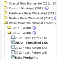
For files that are available for the desired area, the best results are achieved by choosing the Classified LAS version for the selected year (see image to the right). These "classified" files have been post-processed to indicate whether points are buildings, water, vegetation, etc. Views can be modified based on these feature classifications.
There are Filter options above the state map to select the specific files of interest. Use the Custom Selection Button to specify an area of interest. You'll be prompted to click and drag a rectangle to define this area. Once a filter has been selected, a Green Button will appear to the right of the state map (shown below) that indicates the number of files meeting the selection criteria.

Pay close attention to which data set you have selected. It will be necessary to know this information when using the files.
If the file count seems accurate, then click the Green Button to get a prompt for an email address to receive the requested data. An email will be sent in a few minutes to this address with a link to download the LiDAR data files. In Windows 10 this file is placed in the Download Folder. The files will likely arrive compressed (zipped) and appended with a ".zip64" file extension. This file extension should be changed to a ".zip" extension before attempting to Extract from it. Then Extract the files from this zipped file.
LAS Files Requiring Special Attention
There is a defect in MicroStation which does not properly set the elevations of the Merrimack River Watershed files. The elevations contained within these files need to be adjusted so they import properly. The conversion is done by running a utility program called las2las.
To edit these files, run las-convert-z-scale-3048.bat. In some cases it has been necessary to copy las-convert-z-scale-3048.bat into the folder with the LAS files.
When running the program, the user will be prompted for the location of the files and an output folder to store the converted copies. File paths can be copied and pasted from Explorer and should not contain the final \. If there is a space anywhere in the file path, the path must be enclosed in quotes. The program will convert all the files in the "input" folder and place the modified copies in the "output" folder, the folders should not be the same.
To continue this process, see Creating an OpenRoads Terrain from LiDAR Data.