
CAD/D Seed Files
Due to the specialized needs of the various software used during the design process and differing working environments, multiple seed files exist. This page will explain the purpose of each.
International Feet vs. U.S. Survey Feet
When MicroStation was implemented in 1999, seed files were created with working units set to International Feet. At the time, a custom unit needed to be defined to use U.S. Survey feet.
What's the difference?
- One standard or international foot = 0.3048 meters.
- One U.S. Survey foot = 1200/3937 meters.
With the advent of the Geographic Coordinate System within Bentley products and increased interaction with organizations outside the DOT, it is now imperative that we match the units of measure used by survey and construction personnel. In New Hampshire, that is U.S. Survey Feet. However, the National Institute of Standards and Technology (NIST) and the National Geodetic Survey (NGS), National Ocean Service (NOS), National Oceanic and Atmospheric Administration (NOAA), retired the “U.S. survey foot” on December 31, 2022. Although the U.S. survey foot should no longer be used after January 1, 2023, NHDOT has not yet changed the units being used.
CAD/D Seed Files
In MicroStation Connect and OpenRoads Designer, the default seed file is defined by the variable MS_DESIGNSEED. This is the seed file used when the File -> New command is issued.
NH_Seed2D_Design.dgn - A seed file with only a Default model for typical MicroStation work.
NH_Seed3D_Design.dgn - A seed file with only a Default-3D model for creating 3D drawings such as terrain models.
NH_Seed3D_Design_INTF.dgn - Same as above with International Foot working units.
NH_SeedORD_Design.dgn - Seed file for OpenRoads Designer containing both 2D and 3D models.
NH_Seed_MS.dgn - 2D seed file for MicroStation Connect
NH_Survey_Seed_3D.dgn - OpenRoads Designer seed file for processing survey data.
SEED FILES (2D & 3D)
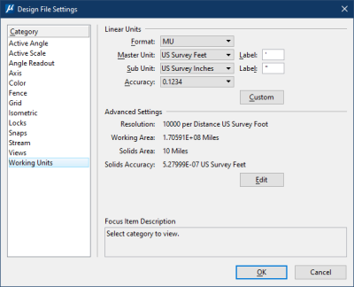
Working Units:
Master Units: U.S. Survey Feet
Sub-Units: U.S. Survey Inches
Resolution: 10000/U.S. Survey foot
Geographic Coordinate System: NH83/2011F